 +7 (727) 236-08-78
Photogrammetric processing of space images is primary in the general cycle of data processing and analysis. CRS & GIS “Terra” provides a full complex of photogrammetric works.
Photogrammetric processing helps to define spatial positions of objects from photographs, obtain their geometric characteristics and create topographic maps.
Space images have complex geometry and require special algorithms for high-precision processing. There are various methods of space image processing, and accuracy of terrain position measurements will largely depend on the method chosen.
An ortho-rectification process is the most critical element in photogrammetric processing and consists in precise geometric correction of images to eliminate distortions: displacements caused by terrain relief; lens distortion; irregular distortions due to deviation in the orientation of camera’s optical axis from nadir, etc.
The ortho-rectification operation requires a digital terrain model of the area under study, outer and inner orientation elements of camera. To determine outer orientation elements of images (scale and position in relation to geodetic coordinate system) the Company uses reference points with their horizontal position and elevation defined by materials of geodetic measurements.
The produced ortho-rectified images are used to create orthophotos, orthophoto maps, etc.
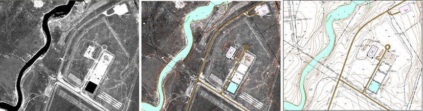
Example of Updated Topographic Map 1:5000 using Orthorectified Data from QuickBird